Spoiler alert! I made it.
When I discovered a ticket to Quito I could pay for with frequent flier miles for a flight that would get me back to my office in time for a weekly Monday-morning meeting, it just made sense to go and stand on the Equator.
So, when my phone lit up with a “CNN Alert” about a huge earthquake in Ecuador one week before my trip, I took notice. Should I postpone? Was it dangerous? Will I even be able to go?
I reached out to the people who had been helping me plan a trip. They told me everything was fine in the regions I was scheduled to visit. The damage was done at the coast in places like Portoviejo and Guayaquil (Ecuador’s second largest city). They said visitors were just what they needed since many people were canceling trips, which meant many locals in the unaffected areas were losing work. I chose not to change my plans.
This near-cancellation did give me pause to ask myself why I’ve embarked on this quest to visit 100 countries. And I’m not the first to wonder. People have asked me,
“What are you looking for?”
I usually reply with the trite, “Not all those who wander are lost.”
But the truth is, I am looking for something. It’s connection. I’m looking for the common – but unexpected – links between people, places, and even ideas. The world is an interconnected system and it’s here for us to explore if we choose to. And I choose to.
The Spanish word for Equator is ecuador, which is how the nation of Ecuador earned its name. Only trouble is, the place should really be called Ecuadores (plural) because it turns out there are two equators. Yes. I know, that doesn’t make intuitive sense, but you’re probably not French. More later?
Although the desire to get a photo of myself standing on the Equator is what prompted my visit, there’s a lot more to the area around Quito than The Line(s). So, in order to see more, I arranged to have a guide. Miguel was proud to show off his city. He took me straight away to one of the city’s most popular spots.
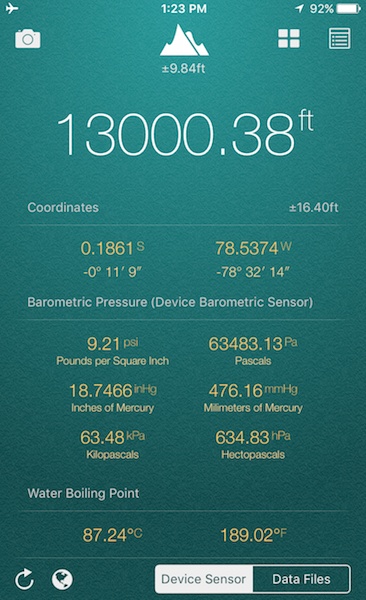
This is very high. It makes it hard to breathe and do just about anything else.
It’s a ski lift called the Telefériqo, which whisks people (with only a few hair-raising halts and bumps along the way) to a volcano overlooking Quito called Pichincha. It’s at about 13,000 feet, which is almost 4,000 feet above Quito, the highest capital on earth. Pichincha last erupted in 2002. By the time I made it up, I could barely breathe, was light-headed, and lost vision with each heartbeat. At altitudes this high in the past, I’ve been supported by medicine that made breathing easier. This time, I stumbled around for a little while, found the exit, fell into the gondola, and headed back down the mountain. As I was reacclimatizing, I noticed a store at the base. Thinking they might offer oxygen, I hobbled in. They had a fine, if not incredibly random, selection of mattresses, wheelchairs, exercise equipment, and pots. Seriously, that was it. No oxygen. So, I had to make it on my own.
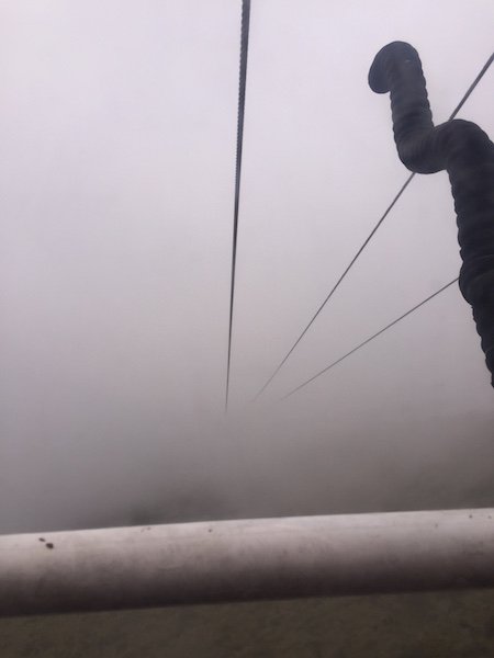
I thought the view was limited because of a lack of oxygen. Turned out I was just in the clouds.
Recently, I began taking Spanish lessons on Skype with a teacher in Argentina named Guillermo. I’m supplementing those Skype meetings with the language-learning app, Duolingo, which rates me at 4% fluency. Based on my conversations with Miguel, the app is being quite generous. It turned out that all of my efforts limited me to brief discussions of,
“los bonitos volcanes, lagos, y montoñas.”
I impressed myself. Miguel, I think, was annoyed to spend hours speaking in the equivalent of Spanish “baby talk.” He was working for a tip so he was still encouraging,
“No! You sound very good, Señor Heb.”
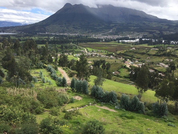
The Imbabura volcano overlooks Puerto Lago.
At one point, we stopped at a waterfall (una cascada), which appeared to be a favorite gathering place for hippies. We climbed (I did so slowly and breathlessly) to the top, doing our best to avoid the body odor wafting off of the hippies.
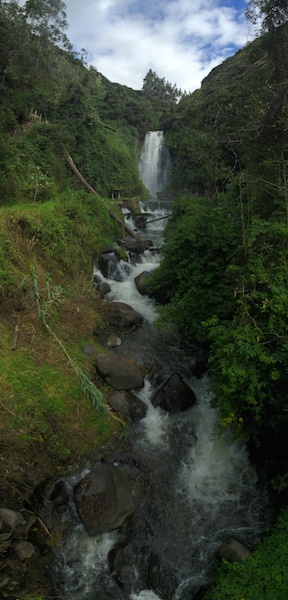
Miguel kept calling this a “waterpark.” Until we got there, I was afraid we’d be walking through Ecuador’s take on Six Flags.
At one point, weakened by the foul odor, Miguel stepped on a dog. In South America, dogs are everywhere. So, stepping on one isn’t big a deal to anyone other than the dog. This one grunted and gave us what can only be described as a dirty look. Once we realized the dog was fine, we laughed. It was, at best, mildly amusing. But, because we could barely communicate, we relived the memory for hours. I’d point at a dog, Miguel would pretend to kick it, we’d laugh. We stuck with this bit for a while. Probably too long. It got old. I eventually asked him if he had a dog and he said that, in fact, he had two: “Okie” and “Dokie.” We didn’t laugh about kicking dogs anymore.
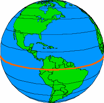
So, back to those two equators. In 1736, some French explorers decided it was time to document – once and for all – the precise location of the Equator. At the time, the best way to do this was to employ the latest technology: triangulation. In order for the technique to work, scientists needed mountains from which to operate. For most of its 24,901 miles, the Equator crosses over oceans and flat land. The Andes offered the French a perfect place to work. Well, perfect except for the thin air, head-shrinking Indians, and other dangers. The project required arduous, back-breaking work and careful calculations. These French scientists climbed up and down mountains as high as 15,000 feet (in their finest breeches, of course, it was the 1700’s after all). They searched for the invisible line. It has since thoughtfully been painted on a nice brick walkway making modern selfies easier than eighteenth-century triangulation.
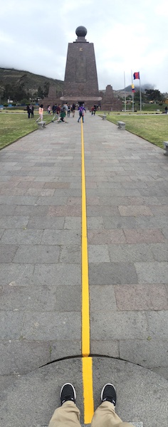
In any event, there was much rejoicing when these scientists finally announced they’d found it. Indeed, it was such a big deal that the nation occupying the spot embraced the name: “Ecuador!” And, in 1982, a 100-foot monument was unveiled in honor of the auspicious discovery. A whole tourist-mecca and city have been built up around this special spot. “Ciudad Mitad del Mundo” is Ecuador’s Statue of Liberty, Yellowstone, and Disneyland all packed into one spot. Unasur, the EU of South America, even put a huge office building there.
And then, in early 2000’s, someone pressed a button and with remarkable speed and accuracy, discovered with 21st-century precision, the exact location of the Equator. And, guess what: the French were wrong! About 800 feet wrong.
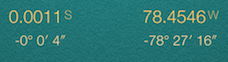
As you can see, my GPS says something different. Guides fend off this criticism in advance by saying that, “Military GPS is more accurate than yours.”
Just to the North lived an unsuspecting land-owner who hit the Ecuadorian equivalent of “bubblin’ crude.? He turned the spot into a campy museum and started charging visitors $4 (Ecuador operates on the US Dollar) to see Ecuador’s unique history, culture, and – of course – its line. You can stand in awe of a shrunken head, taste cacao before it becomes chocolate, and watch a man dance in native clothes. For the finale, you’re led to The Line. There, you can try to balance an egg on a nail (allegedly easier at the Equator, but not for me) and watch the Coriolis Force, which shows that water goes down a drain clockwise in one hemisphere and counterclockwise in the other (I’m pretty sure it’s faked at the museum).
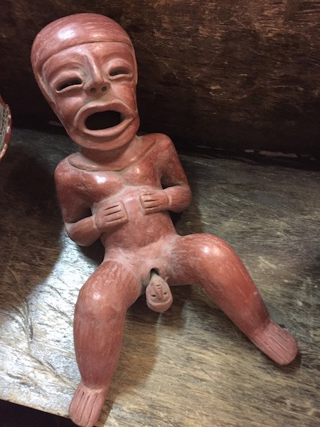
The art is remarkably . . . umm . . . graphic?
Perhaps most interesting was that during the 1736 French expedition, the scientists found ruins of the Quitu culture, which predated the Incas. Oddly enough, the ruins were in a straight line. Who would have thought that this line of ruins marked the exact spot that GPS identified as the Equator? Certainly not the French who could have avoided a lot of effort and centuries of inaccurate photos of happy, but just plain-wrong tourists.
The Quitu-Cara discovered the Equator using ancient techniques hundreds of years before the French and they did it with the accuracy of 21st Century satellite technology.
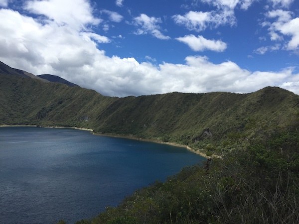
Cuicocha (literally Guinea Pig Lake) is an active volcano with a crater lake and two islands popular among Guinea Pigs. I didn’t eat any (this time).
In terms of destinations, South America ranks as one of my favorites. There’s so much to learn. It’s got a rich and still evolving history, varied and beautiful landscapes, and warm people. Ecuador furthered my already-high opinion of this continent. And finding connections like that keeps me going.
Where to next?
Trackbacks/Pingbacks